Palm Canyon Oasis Ruined in a Blaze

I just read in the San Diego Union of January 26, 2020, that some juvenile pyromaniac set the palm grove in the Palm Canyon in Anza Borrego Desert on fire last week. That spot was one of my favorite day hike destinations in Southern California, and I have been there dozens of times over the years and have taken many a visitor there. Since the offender was a juvenile, law enforcement does not give any details about what happened.

Over the decades, I have hiked the Palm Canyon in the Anza Borrego Desert many times, and I have often documented those trips here. Just a few links, oldest to newest:

The Oasis – A hike a did with my friend Mike (coincidentally the same Mike from the post right below….) in 2008. In that post you can see a few nice pictures of the famous Palm Canyon palm grove, which is visited by about 20,000 hikers a year.

Exploring Climbing of Indianhead – A hike I did with my son Devin in 2010, on our way up the canyon. We did a stop at the palm grove and you see a few pictures of it in this post.

Attempt to Hike Indianhead – Take Two – Another hike with Devin in 2012, making our way farther up the canyon. There are a few more palm groves along the way that the casual 20,000 hikers that reach the first one never see. The hiking after the first grove is treacherous and not for weekend hikers.

Attempt to Hike Indianhead – Take Three – An exploratory hike I did myself in 2013.

And while I am droning on about Indian Head, even though it’s not fully related to the palm canyon, here is my account: Attempt to Hike Indianhead – Take Four – This was my last attempt in 2014, and I think probably my last one altogether for Indianhead. Indianhead shall remain unclimbed by me.

New Palm Grove 2010 – 2017 – An account of 7 years of monitoring the new palm grove. In this post you can see a selfie of myself with the grove in the background.

New Year’s Day a Winter Wonderland in the Desert – the last time I was there with Devin was New Year’s Day of 2019. There are a few good pictures of the oasis.

Here are two clips from the San Diego Union of today:

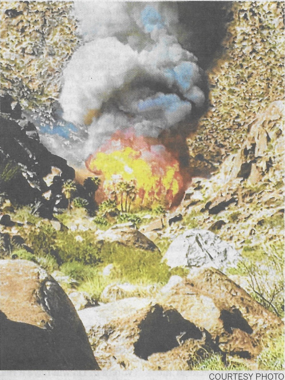
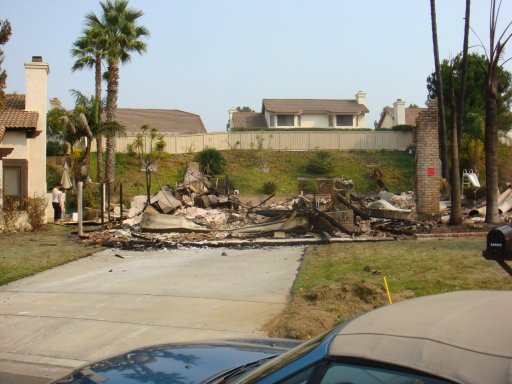
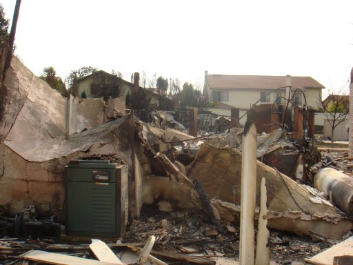
Above with the blaze underway.

Here is what the great trees looked like a few days later, still smoldering.

The grove had last burned in 1970, when a boyscout had played with matches. I remember seeing charred tree trunks there over the years presumably still from that blaze. The rangers expect that the large trees, even though they are all thoroughly burned, will actually recover and sprout new branches at the top.

Also, with all the thick underbrush and shadow eliminated, and boosted by the nutrients of the ash, new undergrowth and seedlings will sprout quickly. I’ll have to go out in a few weeks since I haven’t been there yet in 2020, and see for myself.

I am afraid it’ll never quite be the same again in my lifetime like it was here with me on January 1, 2019:

[click to enlarge]

California Landscape – San Francisco, November 17, 2018

[photo credit: Alcatraz Island Park Service]
The image above is a week ago. The image on the bottom is today.
We’re flying to San Francisco next week. I hope it clears up a bit before then.

Kilauea Volcano – And Pele’s Wrath

We have good friends who live in Hawai’i, on the Hilo side, just a few miles from the volcano. They are under alert watch, and depending on a change of direction of the flow, they might have to evacuate with only minutes’ notice. Some of the flows travel at 17 miles per hour. If the volcano is only 10 miles away, you have maybe 30 minutes to get away.

They sent us the photograph above, taken by one of their friends. This is not lava we’re looking at, but the reflected glow of the lava from the clouds above the volcano.

If you have never been near lava flow, you cannot imagine its power and its terrible force. Lava is nothing like the “red stuff” you had to jump over in the early video games of the 1980s. Lava is 2000 degrees hot, and you can feel the heat radiating off it from a hundred feet away. Standing within reach is burning hot. I have taken a stick of wood (the proverbial 10 foot pole) and poked it near the lava, and it instantly incinerates. Anything in its path is consumed by fire instantly and rapidly.

The Hawai’ians believe in the legend of Pele, the goddess of the volcano. It’s no wonder, after observing the unworldly power of the volcano, that the Hawai’ian people created legends around it.

Kīlauea is a currently active volcano that is located on the island of Hawaiʻi and is still being extensively studied. Many Hawaiians believe Kilauea to be inhabited by a “family of fire gods”, one of the sisters being Pele, who is believed to govern Kilauea and is responsible for controlling its lava flows.

— Wikipedia

[Apologies for the frequent commercials in this video]

The video above is about 13 minutes long and shows very graphic views of the lava, as well as what it does to whatever gets in its way. Roads are obliterated, covered by many feet of black lava rock. Houses in the way simply vanish. When Pele is done, there is literally nothing left.

The Hawai’ian islands have formed for millions of years, and they are still forming now. They are not stopping just because we are here now and building cities next to the volcano. Hawai’i is still growing. New land is created by the volcano spilling lava into the ocean. Decades from now, palm trees will grow on that brand new land and plant roots will start eroding the lava into black soil. And a thousand years from now, somebody will level the ground and build a resort hotel on it.

We can observe geological processes right in front of our eyes.

And we are an awe.

San Diego Fires: View from our Driveway May 15, 2014

Fires

This was the view from our driveway on May 15, 2014 – entirely too close for comfort. Fortunately, the winds died down that night, the weather cooled, the wind didn’t shift inland, and all was well within a couple of days after this picture.

Chariot Fire on Mount Laguna 07-07-13

On July 7, 2013, and the following couple of days, the Chariot Fire burned several thousand acres on Mt. Laguna. Here is a map of the surrounding area showing the location of the fires.

Map Chariot Fire

The video below is a compilation of images taken one per second. This is fairly long, but you can scroll forward and see the progress quite well.

Today, after a hike in the Cuyamacas, I drove back over the Sunrise Highway, which led me right by the burned areas. It was eerie to be driving through terrain that had burned just a few days ago. There were still fire crews everywhere. I took some pictures. As always, you can click on the pictures to enlarge the view.

Laguna Fires 1

Laguna Fires 2

Laguna Fires 3

Laguna Fires 4

Laguna Fires 5

Drill, Baby, Drill

Watch 60  Minutes of May 16, 2010 and tell me when we’re going to build more oil platforms.

How about some more of them dotting the landscape of the Pacific from San Diego to Seattle? How about some in the Arctic Sea north of Alaska?

Just like our banking system is self-regulating, our oil industry seems to know what’s good for the country and the world. Six billion dollars in profits in the first three months of the year for BP gives much incentive to do the right thing for our health and environment.

Might those mid-term elections turn out not quite the way Palin and pals imagined just a few months ago?

Drill, baby, drill!

San Diego Fires – some video

Check “Utter Disbelief” about our friend’s house below.

http://norberthaupt.com/2007/10/23/utter-disbelief-san-diego-fires/

Here is some video done with the firefighters. They are talking about how they saved her house. Had  they not done that, she would have lost her home that morning. The section at her house starts at 2:50 (on the video clock).

http://www.youtube.com/watch?v=khBBWm0NifA

San Diego Fires – The Bad Luck of the Draw

We signed the lease for the new house to move into over a week ago. Then the fires happened. 

This is the house we’re moving into. You can see the house is completely intact, and the one to the right of it is completely gone. You can see the tree is singed on the right side. You can also see some of the rose bushes are brown. About where the people are standing, there was a fence to the right, and to their feet is a koi pond.

house-1.jpg

This is a picture from the driveway of what is left of the house next door. There is another one completely gone to the right of that one.

house-2.jpg

Below a picture from the corner of the property looking south to the two burned homes. In the garage of the second one was a car that had pretty much melted down.

house-3.jpg

One more, stepping further back.

house-4.jpg

The fence was burned next to the koi pond. The pump to circulate the water in the pond was melted. The fish survived.

house-5.jpg

Spared – House Still Standing

The message below is an email I received tonight from a good friend in Fallbrook. Hundreds of homes were destroyed in his neighborhood. Here is the message, which speaks for itself:

Would you let the team know that miraculously our home was spared. We just got word from a friend who is an EMT who stood in front of our home, which is intact. Across the street there is nothing! We even have power and a phone as I just called my number and got my voice message. We are still in Lake Elsinore and will try to get into our home tomorrow to assess the smoke smell and such and take care of our fish and the plants. We leave for our kids in MN on Friday for the weekend and this will be extra special. We grieve for our wonderful neighbors who lost their homes, including the priest who brought us all the avocados. Please thank everyone for their messages of concern, their prayers, and their thoughts. I am copying Norbert too as he was checking his sources for us.  We are very emotional right now and extremely exhausted, but many, many are not as blessed as we.

Utter Disbelief – San Diego Fires

Go to www.sandiego.gov and click on the link List of Fire Damaged Homes and you see all the homes destroyed by fire in Rancho Bernardo alone yesterday. Each number under each street is a burned house, full of furniture, clothes, groceries, decorations, toys and all other possessions. I counted 301 houses destroyed. Each one a total loss for a family. And here it is just a number, so people that are evacuated and cannot come close to their neighborhood can see if their house is still standing.

We made the decision to move a couple of weeks ago. The weekend before last we found the perfect place. We hit it off with the owner. He showed us the property. We looked over the fence to the neighbor’s property. The owner told us about the neighbors. We saw their kids playing on their skate boards in the cul-du-sac. A few days later we signed a lease. We were looking forward to moving in a few weeks.

Then the San Diego Witch Creek Fire started on Sunday. By Monday, Rancho Bernardo was an inferno. There was no way in and out of the community. It was evacuated completely.

Today, a day later, I checked the list above and found that the two homes directly next to us on the right burned down completely.

I am stunned. Will we move into a property next door to two piles of smoking rubble? Is the house we’re moving into damaged? Partially destroyed? I don’t know yet. I will find out as soon as the police takes down the roadblocks and barriers, and we can get into the neighborhood.


And I cannot fathom what it must be like to read your address on a list on the Internet and realize that your house and everything in it is gone. I cannot fathom how this is happening to more than 300 families in Rancho Bernardo alone. I cannot fathom how this is happening to many hundreds of families all over the rest of San Diego County and across Southern California.

I am not even directly affected, but I am stunned and consumed by utter disbelief. I am very lucky.

The picture below shows a different house, about a half a mile away, on the other side of I-15. On the left you can see the house of our friend Linda. It was spared. In the center you see what is left of the house of her neighbor. One flying ember may have made the difference.

A Friend’s House