Hiking: Halemau’u Trail in Maui

Today I hiked the Halemau’u trail in Maui. It starts just below the summit of the Haleakala volcano.

Here you can see me at 8,000 feet (Haleakala’s summit is at 10,023 feet). You can see the clouds below me. This picture is facing north.

There is a good, developed parking lot at the trailhead. Trisha dropped me off at about 8:30am and I was due back by 1:00pm.

This is the start of the trail. It looks pretty benign here, but it’s a very rocky trail. You should wear good hiking boots.

The views all around are of course spectacular. The clouds are way below me. In the distance on the left of the image, the dark area below the clouds, is the Pacific.

The trail is very rocky. This is just one section as an example. It happens to be at a ridge with drops of hundreds of feet on both sides.

The switchbacks down to the crater floor are epic. This picture does not do them justice.

Here is another picture of some of the switchbacks below me. The green area on the right bottom of the image is where I am going.

Finally I reached the crater floor. The end (and turn-around point) of the Halemau’u trail is another mile from here. However, it took me one hour and 45 minutes to get here, and I ran out of time to complete the trail to the turn-around point. Trisha was expecting me at the parking lot at 1:00pm, and with no cell phone reception, I was not able to let her know I’d be late. So I turned around at this spot. I was 2.8 miles and 1,300 vertical feet down, and the hike was downhill all the way. Now the real hike started, going back up the mountain.

This is looking up where I came from, just the first section of it. It took me another one hour and 45 minutes to get back up. I brought two and a half liters of water, but only used about one. It was very windy, as it always is on this mountain, and the temperature ranged from 50 to 66 degrees F.

Bring good boots, bring lots of water, and wear sunscreen. It’s a great hike and I’ll do it again.


Hiking: Eagle Rock

After many years of hearing about Eagle Rock, today we finally did the hike.

The trail starts at the Warner Springs Fire Station. Facing the station, just to the right, there is a gate. Parking is available along the street on the other side. The trail is about 3.3 miles each way. Since we were both under the weather and therefore a little slower, it took us about three hours round trip, plus some rest at the destination. Also, on this June late morning, the temperature was around 83 degrees and it felt very hot out there in the beating sun. I recommend you get an early start, or come during the October – April season. I recommend you bring plenty of water. I used a whole liter and had just a little spare.

The entire trail is along a section of the Pacific Crest Trail (PCT) and if you go in the spring, like now, you’re likely to run into a few PCT through hikers. You can always spot them, scrappy, with a full pack, and the pace and speed of a gazelle.

The first section of the trail goes through a few cattle gates. Be prepared to run into cattle. We heard them nearby but there were none on the trail when we passed.

The trail meanders along a live creek (at least it was live now after all the rains) and it provides an opportunity to wet a bandana and cool off. The trail is also covered by oak groves. Some of the oaks are huge and  look hundreds of years old.

The vistas are endless. Think Ponderosa.

Finally, we’re on the last quarter mile. The outcropping in the distance is the back of Eagle Rock. You can see some hikers on the trail. We must have seen at least 100 people going in and out this morning.

Finally we have arrived. Here we are posing in front of the famous Eagle Rock.

On the way back I kept on the lookout for some motifs for painting, as I always do. Here are some cactus blossoms that might make a great 36 x 36 floral arrangement for my collection.

Here is another one that Trisha spotted. It’s a different type of cactus.

Trisha made sure I took a picture with her in it of the same scene – so you have “Trisha for Scale.”

Hiking to the Hollywood Sign

For the over 45 years that I have visited Los Angeles, I have told myself that one day I’ll be hiking up to the Hollywood sign. It was one of those things that just never happened, because it requires planning, preparation and then following through.

Well, yesterday was finally the day. A great help was that an associate from work I recently got to know lives in the neighborhood right below the sign, and he was gracious enough to give us the guided tour.

The photo below shows the sign from a neighborhood street were we walked up.

The entire hike round trip was about 4.5 miles with an elevation change of 900 feet. It’s all paved road, so no hiking poles are needed, and a quart of water should be plenty. It took us about an hour going up, and as much coming down.

About halfway up there is a good spot for a picture. Just above the W you can see a ridge and you can make out people on top of it. That’s where the next few shots are made from.

Finally at the top, the sign is all fenced in to protect it from vandalism, which was rampant in the early years. The sign was first put up in 1923 by a real estate company by the name of Hollywoodland. It was lit up at night and must have been a gaudy site. The intent was to keep it there for only a couple of years, but it “grew roots” and it’s become an iconic landmark recognized around the world, of course.

In the picture above you see the letters from behind. This is how close you can get. There are actually police up there that prevent any trespassing. Each letter is 46 feet tall. From right to left you see “LYWOOD.”

Looking down into the valley, the entire Los Angeles basin was shrouded in smog. On a clear day, one could see all the way to the ocean, and the entire panorama would stretch from downtown Los Angeles in on the left side to Hollywood and Century City on the right, with the Pacific Ocean in the background. Yesterday, all we could see was murky skylines that didn’t even show up in these photos.

Our friend took a panoramic of us at the top with all the letters visible.

On the way back, I looked up to the ridge from where we took the panoramic shot just a few minutes before. You get a sense of how many tourists there are. We must have walked past hundreds on our way up and down. It’s a very popular destination, of course, with the mountain being in the middle of the Los Angeles sprawl with more than 10 million population within a couple of hours of driving.

We finally hiked the Hollywood sign. Check!

Hiking Bottle Peak in Escondido, California

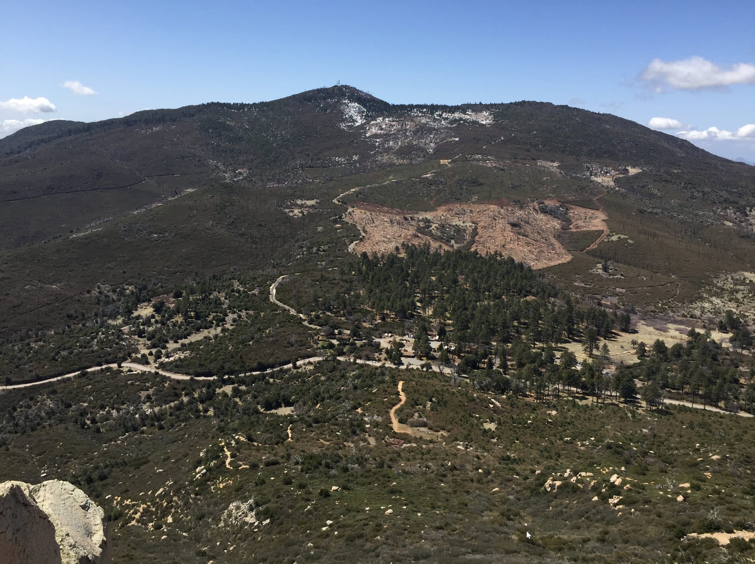
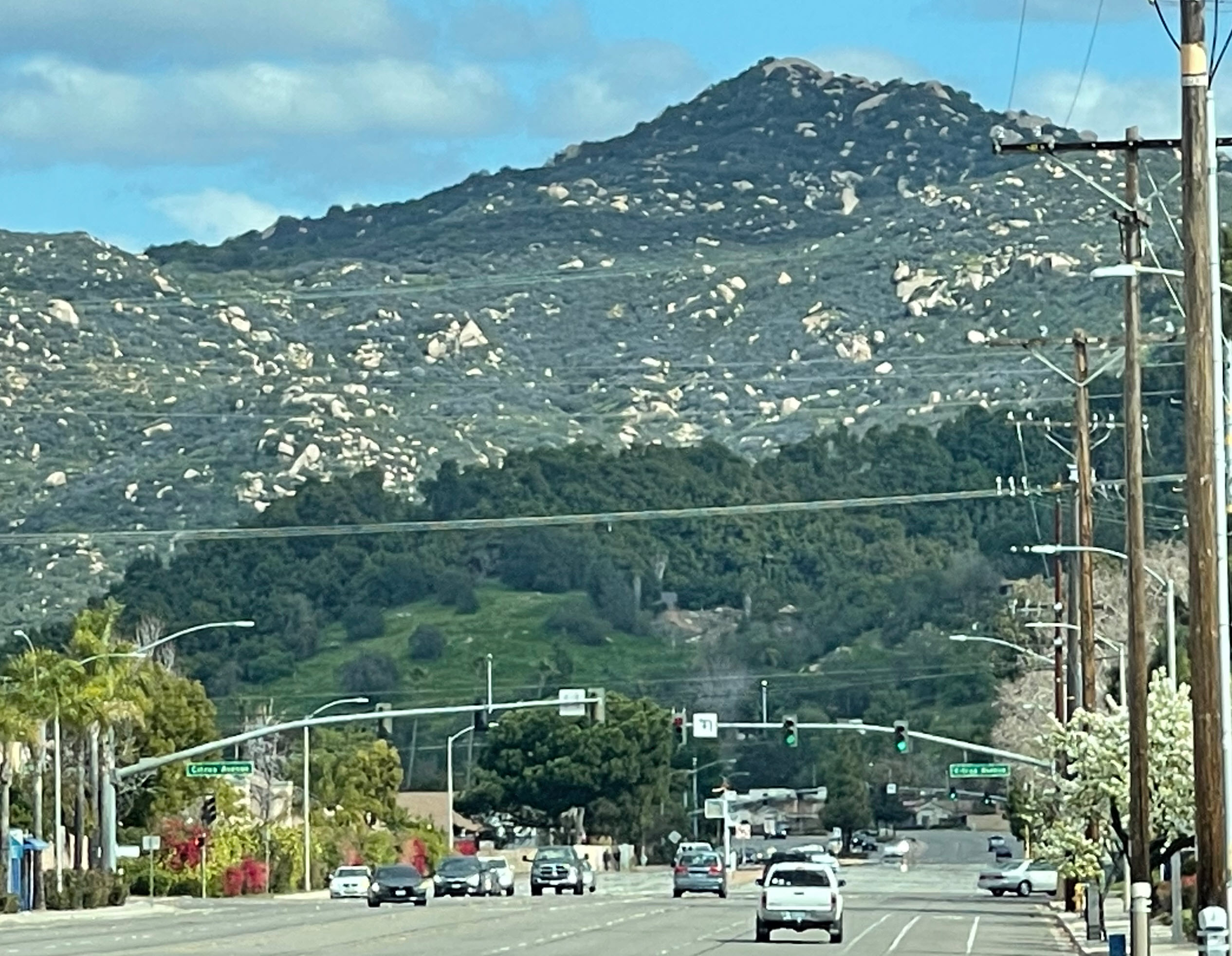
Bottle Peak is the mountain that towers over the end of East Valley Parkway, which is a long, straight and busy road in eastern Escondido. I have seen that mountain there for decades, and I have always wanted to climb it. I finally did it last Sunday, Superbowl morning.

It looks simple enough. It’s not far away. Here is another photo taken from closer to the end of Valley Parkway:

You’d think there are busy hiking trails and scores of hikers who climb that mountain every day, and particularly on the weekends, sort of like Iron Mountain in Poway. But no, it’s actually almost impossible to find the trail. I googled and found a few hiker blogs who had been there, and I checked their instructions and maps. I did an exploratory drive almost around the mountain and found nothing but locked gates and no access to the various roads.

Here is one blog post:

Iron Hiker: Bottle Peak

Here is another one that was more helpful to me:

Bottle Peak, Tombstone Peak | Nate’s Hiking Blog (natehikes.blogspot.com)

A couple of weeks earlier I actually used Nate’s map in his blog and tried to find the trail starting at Lake Wohlford Road. I had his map and his pictures, and I scrambled around in the impenetrable thickets on that slope for an hour and I could NOT find the trail. I gave up.

For this hike, I went over to Oakdale Road to find the beginning of the alternate and shorter route he describes. When I got there, I found a locked gate and No Trespassing sign. This didn’t look like something I should mess with.

About a hundred feet up the road towards the west from the gate I found a little access trail, but again a No Trespassing sign. I respect private property, so I thought I should not enter there either.

Disappointed, I went back to the beginning of Oakdale Road, about a quarter of a mile, right by Lake Wohlford Dam and found a creek I could climb up in. I parked my car in a small dirt pullout by the creek. No signs here.

And up the creek bed I went for 5 or 10 minutes of heavy scrambling. Sometimes I needed to pull myself up on tree roots. This is definitely not the intended trail, but I didn’t technically “trespass,” right?

The creek reached the access road that started down by the gate, and I proceeded up that. Oh, well, trespassing again. And here the journey starts. Below is my map and you can see that it was not trivial for me to find the actual trail. I marked the gate for you where I should have started at the Private Property sign, because, as you might see, that’s how I hiked back out. My start route up the creek ended up simply meeting that private road.

Then you can see several false starts. I first missed the trail head up the mountain and I turned around. Once on the trail, I also missed the main trail and went on a left fork which fizzled into nothing and a pile of trash. Eventually I found the right trail to the peak.

Heading up the road there is a large boulder with graffiti on your left. That’s a landmark.

Shortly after that, I got to a ridge, a highpoint on this road, with a rusty remnant of a gate. The actual trail up the mountain starts at a clearing on the left just 50 yards beyond the rusty gate.

The first time I got there I missed the trail and soon reached this sign:

See the first box: No Trespassing.

There are lots of access roads and a lot of neat peaks to climb up there, as Nate describes in his blog. But to get there, I had to trespass. They definitely don’t want any hikers up there. I think I need to call the information number shown on the sign and find out what’s up with all the rules.

Important however: if you try to climb the mountain and you get to this sign, you have gone too far and you need to turn around.

This is the spot where the trail starts, heading due east up the mountain.

I took a waypoint to save any hikers the hour I tooled around before I found it. Here it is: N 33.16461 W 117.00577, Elevation 1643 ft.

A few steps along the trail there is a little footbridge, which I found odd in such a desolate area.

As I told when I showed the map above, I made a left turn at a Y which turned out to be wrong. I went up a fairly overgrown trail and there was lots of old trash. This is a car door with bullet holes in it. Who takes a car door up a mountain trail just to shoot at it? From the looks, it’s probably been there for 60 years.

Finally the trail fizzled out completely and I could go no further. That’s where I found this. Who carries buckets stuff up a mountain and then leaves it all there? What’s the point?

I suspect this was at one time a camp of undocumented migrants. I can’t think of any other explanation why somebody would carry cans and jars and blankets and all kinds of other plastic trash way up on this remote trail. I could have filled a dump truck with various trash just on this little side trail.

Sad.

Finally I found the actual trail and it didn’t take me long to make it up the remaining 500 vertical feet to the peak. This photograph is near the peak. The boulders are huge.

Looking back, there was a good view of Tombstone peak on the left and Stanley Peak on the right. I have written about hiking Stanley Peak here.

Finally, the peak. There is a huge granite slab at the peak. The blue arrow points to the top, marked by a concrete platform that used to be the base of a lookout tower. Nothing but the slab remains. I left my poles at the base and scrambled up.

This is what’s called a Class 3 scramble: Moderate scrambling on steep, rocky terrain that requires handholds for upward movement and safety.

My hiking boots have good tread, but I needed my hands to pull myself up. I made use of the sturdy oak trees on the left side to pull myself up the first 6 feet, which was the steepest and most slippery. After I got past the tree, I just crawled up like a turtle until I got to the ridge, and then I walked the remaining 10 yards to the right to the top.

My 66-year-old self is not the same rock climber I was in my twenties, so I was quite proud of myself. But I was a bit nervous, because I was alone, and all it would take is a little slip of the foot….

I did come down on my butt, very slowly, and I would certainly do it again. It was worth it.

The view from the top is 360 degrees and priceless. I could see the Pacific in the far distance. The arrow points to Valley Parkway in Escondido, where the first picture in this post was taken.

Here is the same view in a full-sized format, so you can click on the picture and enlarge it.

I don’t have an exact mileage and altitude profile I can share, since I made so many little side trips finding the correct trail. I am baffled by how difficult it is to get there. I was out there for about two and a half hours and I did not see another soul. This was a Sunday morning, and nobody was on that mountain. It seems like a waste of nature, so close to the city, yet so far away from access.

I will find out from the Department of Parks and Recreation what the deal is and I’ll post this when I know.

All I can say is: I finally hiked Bottle Peak.

Disclaimer: I told you here that I had to go through several No Trespassing areas to get to this peak. I am not telling you that you should do that, too. However, I have not found any way up this mountain without trespassing – yet. 


Hiking Palm Canyon – Jan 1, 2023

Even though it rained hard in Southern California today, I went to Borrego Springs for my annual New Year’s hike up Palm Canyon.

Here is this year’s photo of the little palm grove. Not much has changed since last year. See last year’s post here.

Of course, there has to be the obligatory selfie at the grove itself:

The steel post under my leg is holding up a sign that says “Area Closed, Do Not Enter” which I tried to cleverly cover up. But I forgot about the post. It would have made more sense to just show it. — I guess I’ll do it next year when I go back.

The seedlings after the fire on the bottom are now coming in strong and make for an impenetrable thicket.

This year, for the first time I can remember, it rained when I was there. I got cold and wet through. Here is a shot facing down from where I am standing at the grove – you can kind of see the rain.

Hiking the Palomar Mountain Overview Loop

Today I hiked the Palomar Mountain Overview Loop, which is #17 in Sheri McGregor’s book 60 Hikes within 60 Miles of San Diego.

But before I started, I decided to not use the regular paved road up to Palomar that everyone takes. I took the Nate Harrison Grade Road, which is unpaved and winds it way up the mountain from Pala on the southwest slope.

The road is fairly well graded in the lower sections.

It was a cloudy and cold morning. Looking down into the valley, I often could not see anything but clouds.

In the higher sections, the road got quite rough. I would not want to do it without 4-wheel-drive.

But with a high lift and large tires, my Mojave was just purring up the mountain. It was made for this. Here it is parked by the edge, with sky all behind it.

Once I got to the higher elevations, the clouds thinned out, and the sky was bright blue.

Once I reached the state park at the top, I noticed a tribute plaque to the California Conservation Corps, or CCC as we call it. My son Devin has worked for the CCC many years and is an avid conservationist. He follows a long tradition of Californians dedicated to the preservation of the beauty of our land.

Finally I got to the trailhead.

There is a short spur of paved road that I walked down, and then I turned right onto the trail.

Here is the map of my hike. I followed it exactly as the book described it, starting at the parking area indicated on the red bubble of the map on the bottom. There is also a parking area in the Upper Doane Valley, right by Doane Pond. That’s where most people start that hike. But I’ll get to that.


I hiked the loop counterclockwise, turning right. On the map, you can see yellow, orange and red where I hiked fast, and green and blue where I hiked slowly, and dark blue where I stood and caught my breath. As you can see, I hiked fast in the first half because it was all downhill. I started at about 5,200 feet and Doane Pond is at about 4,500 feet elevation. But then, from the pond forward, it was all uphill and quite steep in sections!

If I had started out at the pond, I would have first gone uphill, and then downhill, which is more like a normal hike on a mountain.

Shortly after starting out, there is a very nice view of the world-famous Palomar Observatory in the distance:

The trail is quite shaded most of the way. Here is a typical view.

And another view:

At one point there is a section of old fence that has all but disintegrated. Time kills all fences in the wilderness.

Down in the valley, the trails are a little more level and are skirted by pleasant meadows on both sides.

Here is a nice view of Doane Pond from the south side. Behind the trees in the center is the main parking lot from which most folks start this hike. But even today, an a holiday weekend Saturday, I only saw another five to ten people on the trail. It was very quiet.

My hike was four miles long (it felt longer for some reason) and took me exactly two hours. I took ample breaks to snack, catch my breath, and take pictures. When I finally got back to the car, heading down for the main road, I pulled over once more and took one photo from the crest of the mountain down into Pauma Valley far below.

The Palomar Mountain Overview Loop Trail is a nice, moderate hike, with a good elevation change to get your pump moving. And if you have an offroad vehicle, I can recommend taking the Nate Harrison Grade Road up. I saw not a single other car on that road on my way up.

Hiking Palm Canyon – Jan 2, 2022

Today I went to Borrego Springs to do my annual New Year’s hike up Palm Canyon. Every year I take a picture of a little palm grove from the exact same spot. If you want to read up about some more history and see older pictures, this post gives you a few links.

This year, I took the picture with myself in it for scale:

After taking this picture, I hiked up to the oasis.

After many decades of growing, some idiot kids burned it down in 2019. All that remained were the charred stumps Fortunately, nature is resourceful and pretty much all the trees came back. With the “skirts” all gone, and the underbrush completely burned away, there is now a thicket of greenery on the bottom.

The forest service is also keeping people out of the grove itself to give it a chance to recover.

I have done this hike on New Year’s Day or the days after for decades now. But it’s special ever year.

Visiting Devin in Yosemite

Last weekend I went to the California Conservation Corps (CCC) backcountry program camp where Devin has been the supervisor since late April. In the first few months, the corps goes out and does “front country” work, where they are within access to a vehicle for supplies and connection. But in the latter months they hike out into the backcountry, where they sleep in their individual tents, work a full-time job doing trail maintenance, then hike back to camp for the night. Once a week, on Tuesday, a supply mule train comes up with provisions for the week and other needs, and takes back the trash. On weekends, the crew goes  — backpacking.

I visited the camp at Sunrise Lakes in Yosemite.

On the way there I stopped at Olmsted point (see map below) and got a good view of the famous Half Dome. You can see how smoky the air is. It is actually due to a management fire in Yosemite (induced by the forest service) and they have signs up telling people not to “call in” the fire. Unfortunately, Half Dome was in a smoky haze.

Here is an overview map [as always, click to enlarge pictures]. Olmsted point from where I took the photograph above is indicated (blue arrow).  You can see the location of Half Dome (green arrow), the peak of Clouds Rest (orange arrow) and the location of the CCC camp where I went (red arrow).  In the lower left of the picture is Yosemite Valley, which is what most people think of as Yosemite. In reality, it’s a huge area of wilderness.

My hike started at the Sunrise Lakes Trailhead off Highway 120 right by Tenaya Lake. The colors indicate my speed. Red is fastest, blue is slowest. You can see where the switchbacks were and of course where I rested by the blue.

Here is a typical section of the trail. Huge boulders as one expects in Yosemite are everywhere.

Another section of trail.

Here I arrived at the “First Lake” and you can see the spot on the map above. The lakes are pristine, and as you can see, there is nobody there.

It took me about three hours to get to the CCC camp. Here is Devin at the hand washing station.

The crew does trail maintenance work, which would be felling trees, building rock steps, filling in washed out gaps, building retaining walls. All in all backbreakingly hard labor. That’s why it says on the back of Devin’s CCC business card: “Hard Work, Low Pay, Miserable Conditions and More.” Here you can see their “tool shed” with sledge hammers, chain saws, and various gear. A tarp above keeps out the rain.

Here are more tools, clippers, rakes, shovels, all nicely organized.

Here is a picture of the “living room” which consists of a fire pit in the middle, log benches all around, and a large tarp over the top to keep out the rain, but mostly the sun. To the left is the kitchen. All the food needs to be stored in bear boxes, which are those big brown cases.

The crew members pitch their tents in the surrounding area, usually away from others for privacy and quiet. So they are actually quite spread out. Here is Devin’s tent, where he has lived and spent pretty much every night in the last two months, except for when he went off backpacking on some weekends. This is his home. Right now, the temperature goes down to the low forties over night, so it’s quite nippy already, and it will get much colder over the next few weeks. The sun goes down at about 7:30pm and it’s dark very quickly, and stays dark until about 6:00am. That makes for a long night in the tent.

There is a spot on a giant granite incline not far from the camp where they get phone reception. The picture below shows me on that spot. You can see the peak of Clouds Rest (red arrow), a sliver of Half Dome (green arrow) and the approximate spot of the cell phone tower (blue arrow) over Yosemite Valley, about 13 miles away, which brings in the signal. I got 3 bars on my iPhone from that spot, but when I hiked back the couple of hundred yards to the camp – nothing.

Below is a close-up of Clouds Rest and Half Dome from that same spot.

And while I was there, I checked my messages and my email. Here is yours truly, the Software CEO doing a bit of work while out hiking, answering a few urgent emails, making a few appointments, before walking back “off the grid” to get some dinner at the camp.

The next day we hiked down to the trailhead. Here is a picture of Devin in front of Tenaya Lake. The peak behind him is Tenaya Peak. That’s a 10,301 foot peak with no trail going to it. The next day, Devin was going to do a solo hike off-trail to that peak from the CCC camp, which is located to the right behind the peak. I wasn’t comfortable enough for cross country hiking at that altitude for that distance (at my age) so I didn’t volunteer to participate. Devin, as a crew supervisor, carries an emergency satellite phone with GPS, so he feels safe enough to go alone.

As I am writing this a couple of days after, I know Devin made it and has already sent me a picture from the top, looking down on the lake, But that’s for another post.

Another picture of Tenaya Lake, facing due east.

While we there, as we’re crossing the highway, I found an iPhone in the middle of the road, obviously run over by cars already. But as I picked it up it still worked and showed a photograph of the owner and his wife on the cover. So we hiked around a bit trying to find them and give them back their phone, but no luck. I decided to take it with me, and wait for the first incoming call. Sure enough, about 3 hours later, as I had already left Yosemite, that call came in and I was able to connect with the owner and arrange to return the phone to him, albeit run over and scratched.

All in all it was a wonderful weekend. I saw Devin for the first time in 6 months, and were were able to catch up on life. I got in some good hiking and fresh air. I tested a new backpack and sleeping bag, and I am already looking forward to going back. To me, Yosemite is one of the best places on earth.

Devin on Clouds Rest in Yosemite

Here are some pictures Devin sent me this morning. He is on top of Clouds Rest in Yosemite. This is a 9,931 foot mountain in Yosemite with amazing 360 degree views of the park. It’s not the highest peak in Yosemite, but since it’s so close to “the Valley” it’s very prominent.

I’ll be visiting him in camp at the beginning of September, and I’ll definitely hike to the top of this mountain while I am there. It’s about a five-mile hike one way from camp, or about 10 miles from the trailhead. As always, you can click on the pictures to enlarge them – and when looking at this view, you had better do that!

Here is a selfie of him with Half Dome in the background and the Yosemite Valley to the right.

Here is a better view of Half Dome and the Valley.

If you want to read about my climb of Half Dome in 2012, here is the link. It was one of the most iconic hikes of my life. I am looking forward to hiking Clouds Rest now.

Thanks for the inspiration, Devin.

Off-Roading Challenges in the Anza Borrego Desert


There are some beasts in the Anza Borrego desert.

No, this is not photoshopped. This is a real photograph of me this afternoon.

Devin Will Be Off Again

I just re-read a ten-year-old post about Devin is Off.

He went into the wilderness with the California Conservation Corps famed elite Backcountry Trails Program. About midway through his stay, I hiked in and documented that trip here.

You can see how the dreadlocks had grown over the months in the bush in one of those photographs.

Devin now works full-time for the California Conservation Corps as a manager. This is the back of his business card:

Hard Work. Low Pay. Miserable Conditions and More. That’s the CCC for you.

Now, 10 years later, Devin has been chosen as one of the six Backcountry Trails Program supervisors. He will go out and do the same thing again, but this time as the leader of a team of 18 corps members. He got a coveted slot in Yosemite.

Of course, that means I get to hike into Yosemite to visit him and the team sometime this summer. He says that I’ll only be allowed to visit if I teach a weekend course as a visiting lecturer in some related subject. I am very much looking forward to that adventure.

If you want to learn more about the CCC Backcountry program, visit their website here.

Hiking Stonewall Peak

Stonewall Peak is one of the more dramatic peaks in San Diego County, and I can’t believe that I haven’t hiked it before in all these years. I have been so focused on the other prominent peaks on the west side of Highway 79 at Cuyamaca, like Middle Peak and Cuyamaca Peak, that I have missed it all these years.

We parked the car at the Paso Picacho campground, which is just a couple of miles south of Cuyamaca Lake on California Highway 79. There is a $10 day use fee to park there, but it’s well worth it, not just for supporting the park, but for the bathrooms, waterspouts, ample picnic areas and all-around safety of a patrolled campground.

[click on images to enlarge]

Here is Trisha with the Jeep. I recently bought an offroad monster so we can get to remote areas at the end of dirt roads that would otherwise not be accessible to us. But not to worry about Paso Picacho. It’s right off the highway and a Prius can do it.

Here is the view of the peak from the parking lot.

The campground’s elevation is 4,881 feet. With the peak at 5,730 feet, the climb is about 900 feet or so. Here is a map of the trail.

You can see the trailhead starts directly across the highway from the entrance. It ascends steadily over exactly 2 linear miles. It took up a leisurely hour or so to make it to the top.

Here is a view of the whole mountain from the beginning of the trail, not obscured by trees.

The entire mountain is dotted with massive oak trees that burned many seasons ago and are now all white, making for some stark and dramatic pictures. You can see the trail is mostly well developed and easy to walk.

Well, mostly: Here is a picture of me at the top of a rougher section, of which there are plenty. In the lower left you can see remnants of the last snow, which fell about a week ago, which reportedly covered the Cuyamaca area with 18 inches of powder.

The peak consists mostly of exposed granite. There are some man-made stairs to help hikers across a few more exposed areas at the very top. You can see I am hanging on to the handrails.


And finally we reach the peak. It was 51 degrees outside, and the wind was whipping. I put on all my layers and I needed them.

The views are amazing. I took the picture below pointing the camera almost straight down. The stonewall, after which the peak is obviously named, is almost vertical. I would have loved to try this during my rock climbing years. Down in the distance, in the upper right of the picture, is the campground from where we came, and Highway 79 is clearly visible. Some traces of the trail on which we hiked up are also there in the middle of the picture.

Looking up from the same spot, and pointing the camera level to the west, we can see the broad expanse of Cuyamaca with the peak in the middle.

From the same spot, turning north, we can see parts of the mountains of the Anza Borrego desert on the right side. The ridge in the very back, right below the large cloud in the center, is the massive Mt. San Jacinto, with 10,833 feet (3,300 meters) one of the tallest mountains in Southern California.

And when I saw it there I decided to go back there this summer. It’s been a few years.

Hiking Stonewall peak is something you can easily do, waking up on a Sunday morning in San Diego, having a leisurely breakfast with the morning paper, then driving up to the mountains, doing the round-trip hike, and be back home well before sundown. That’s one thing I love about this area: the mountains are right there!

Hiking Burnt Mountain on Daley Ranch

Here is a hiker’s map of Daley Ranch.

[as always, you can click on the image to enlarge]

In the upper left corner there is the Engleman Oak circle trail basically around Burnt Mountain. You can walk or bike there from the main entrance by Dixon Lake, but it’s a longish hike. But you can you also access it from the Cougar Pass trailhead. Here is a more detailed section of the same map:

The red arrow points to the trailhead. When you use Goggle Map directions, even coming from the south in Escondido, it directs you to the Hidden Valley Road exit off I-15, which is out of the way. The easiest way to get there is to just go north on Broadway in Escondido. After a while it becomes rural. About five miles out of town, there is a turnoff labeled Cougar Pass Road. This is a dirt road with some washboard damage that snakes up the hills, but it’s totally safe for a regular vehicle. I might note that the Google Maps-recommended way also includes several miles of dirt road driving. There is a good parking lot at the trailhead and there is always enough space, since it is fairly remote and not well-known.

The Cougar Ridge trail ascends sharply from about 1,200 feet at the trailhead to about 1,900 feet where it joins the Engleman Oak trail. The last section is a steep fire road, with direct southern exposure to the sun all day long. I have to pace myself there to keep the heartrate reasonable. Once you turn left on Engleman Oak, it becomes mostly flat. The trail is dotted with boulders on both sides, and partly shaded by a lot of old oaks.

I marked the peak of Burnt Mountain with the blue arrow. This is a rounded, rocky peak with no published trail to it. But on previous hikes about at the spot marked by the green arrow, I noticed a faint foot trail into the brush.

If you look carefully, you can see the faint trail in the foreground on the left side. The peak is not directly visible behind the high point in this photograph. It’s all boulders and brush. But the foot trail looked promising. Every time before, when I was there, I was alone and I didn’t think it would be smart to hike there by myself. It’s mountain lion country. But more importantly, if I were to injure myself through a fall, nobody would come by to save me. Nobody would find me. Not a smart thing.

So last week, my son Devin was in town. Devin is a wilderness first responder and very experienced hiker and climber. The right guy to take along when you’re scared of going on a sketchy, unknown hike by yourself. So we headed up.

Here is Devin taking a selfie of us at a rest stop along Cougar Ridge trail.

After twenty minutes of scrambling through steep tiny trails, under bushes and through brambles, we got to the top. There were a few places that required some bouldering, using hands to pull up between large rocks, but nothing too scary. We both wore long pants in anticipation, something I would strongly recommend. I got my arm scratched bloody somewhere. Here is one of the views from the very top.

Here you can see the elevation of 2,222 feet at the peak, which is about 300 feet above the plateau where the foot trail started.

Here is another shot from the top, pointing east. On the bottom you see the Engleman Oak trail from the plateau where we started. The green arrow points to Cuyamaca Mountain some 50 miles away. At over 6,000 feet, it is one of the highest peaks in San Diego county. The red arrow points to the top of Stanley Peak, which I have hiked and described here.

And of course there is always a victory photo when there is a partner to take my picture.

Here is a shot of Devin on the way down on the barely discernible trail.

Here is the profile map of our hike. The green arrow points to the start of the foot trail. On the way back, we turned left on the Burnt Mountain trail rather than completing the Engleman Oak trail, which is a fire road, versus Burnt Mountain trail being a nice trail. The same thing on the way back, we took the Bobcat trail back to the other side, rather than continuing down straight the Engleman Oak road, which is very steep, rocky and not all that inspiring.

The whole trip, including the peak and back, took three hours and was 5.40 miles long. We took plenty of rest on the top, so it can certainly be done faster if need be.

California Winds

Last Tuesday we had high winds in Southern California. Blue sky. 40-mile-per-hour winds. At one point we heard a loud banging outside and we found that the wind had torn off a section of the shingles on our roof and they were bouncing around on the roof and flying around the neighborhood. A section of our roof shingles was gone. It also blew over some fences in the area. The wind kept going for about 24 hours.

Yesterday afternoon I went for a quick hike up the Daley Ranch trail when I saw that the sign had been blown over.

You might remember this sign from a previous post about hiking Stanley Peak. Here it is again:

The wind on Tuesday obviously was strong enough to topple these posts.

Here is one of the posts broken off. I put down a banana for scale. I also measured them. They are 14 inches (35 cm) in diameter., and they snapped like a match.

Here is am, posing one more time with the sign. Will it be put back up?

Hiking Palm Canyon – New Year’s Day 2021

As I try to do in the first few days of every year, we hiked the Palm Canyon today.

I always visit the same spot every year and take the annual picture of the “New Palm Grove” I discovered in 2010. You can see some of the history here. The last time I went with Devin on January 1, 2019. Here is the post from that day. I was not there at the beginning of 2020, but I found out in a newspaper article that the grove had burned. Here is the summary from that. Since it was burned, I didn’t try to go last year, fully expecting that the trail would be closed.

But we went today, and I am so glad we did. As always in my pages, you can click to enlarge the pictures.

On the way there, from a lookout, I can never resist taking a picture here of the Anza Borrego desert, as far as the eye can see. In the background on the right, you can make out the Salton Sea as a blue stripe. The dark spot on the left center is the town of Borrego Springs. The picture is taken from over 2,000 feet above the desert floor.

Here is the trailhead. The trail starts here and goes up about a mile and a half.

Here I am at the start of the trail – with my trusty old desert hiking hat that has accompanied me on hikes for 40 years.

Santa brought Trisha a tripod and remote trigger – we’re testing that here. Banana for scale.


The terrain is very rough, and sometimes you get lucky and can spot bighorn sheep here in the mountains. Not today, though.

The only wildlife was us. Here is Trisha with a giant ocotillo plant. If there had been more rain this year, it would be green by now, but it’s been very dry and everything is still dormant.

The trail us rough and covered with boulders, which makes for exciting hiking.

Finally, here is the “new palm grove” that I take a picture of every time I come here. The tiny trees  that were no bigger than my hand in 2010 are now substantial palm trees.

Same picture, but this time with Trisha for scale. The creek, which had water at this time of year in most years, was completely dry today.

And here it is, the large oasis, in all its glory. All the trees are charred from the fire on 2020, but have come back. YES!

This was our endpoint. The trail ends here, and hiking further up the canyon is possible, but extremely rough. The grove itself is now blocked off so it can recover. But here you see the grove the way it looks today.


For comparison, here I am two years ago to the day, on January 1, 2019, when Devin was with me. You can see the same trees, but with age-old “skirts” of old palm fronds which serve as habitat for all kinds of wildlife. The skirts are now gone, the trunks are charred, but the trees have come back. Due to the additional light, the new undergrowth will come in thick in the next few years. And the circle of life has begun again after the blaze.